Navoi Region
Navoi province is located in the central part of Uzbekistan. Area of the province constitutes 110.8 thousand square kilometers or 24.8% of total area of the country. Population is 829 thousand. The province borders with the Republic of Kazakhstan in the north and with Jizzakh province in the east, with the Republic of Karakalpakstan in the west, with Samarkand, Bukhara and Kashkadarya provinces in the south. The province includes following 8 districts: Kanimekh, Kyzyltepa, Navbakhor, Navoi, Nurata, Tamdyn, Uchkuduk, Khatyrchi and following 6 cities: Zarafshan, Karmana, Kyzyltepa, Navoi, Nurata and Uchkuduk; there are also 8 urban-type villages and 53 villages. The north-western part of the province is occupied with Kyzylkum plateau; Nurata mountainous ridges stretch in the east and the south of the province is fringed with Zarafshan River. The climate of the province is sharply continental and arid; summer is dry and hot, winter is relatively cold and snowless.
Navoi city
The administrative center of the province is Navoi city which was named in honor of the Uzbek poet and philosopher, scientist and statesman Alisher Navoi. City, located in the Zarafshan river valley and 122 kilometers from ancient Bukhara, was built using a general layout plan in 1960’s. The population of Navoi city is about 129,1 thousand. The creators of the city in the desert provided a compact construction and efficient system of engineering services.Alisher Navoi
Best places to visit in Navoi Region:
Nurata
Chashma — is a place of the faithful’s pilgrimage and one of the significant religious centers of Islam in the region. The complex of religious constructions «Chashma» (tadjik word «chashma» means «spring») includes the spring, a well mosque «Djuma» and khamom (bathhouse). According to legend, allegedly 40 thousand years ago a meteorite fell to the earth. The crater formed after it blocked up to miraculous healing spring. Water temperature in the saint Nurota spring is constant, about 19,5 degrees. Fifteen microelements including gold, silver, iodine and bromine are found here. Bromine gives a sedative effect and has a wholesome influence on nervous disorder and gastrointestinal problems. The fortress built by Alexander the Great, its represent one of the most ancient and significant archaeological monuments of the region. The monuments consists of several parts. «Shahristan of Nurota (settlement of antiquity) 500×500 meters in size, was enclosed with a large wall and towers. Entrance was located in the middle of the north wall. From the south, wall were nearly set against the rocks. The south wall was strengthened with four round and half round towers. The north-west part was vastly destroyed. A construction in the form of a corridor 130 meters long and 16 meters wide stretched from the south-east tower. It was ended with a rectangular 26×26 meters tower. Length of the tower together this corridor was approximately 130 meters». The construction of a unique underground water-pipe near Nurota — kariz system, is connected with the name of the outstanding commander, Alexander Great. Kariz is an ancient water-pipe laid from the spring to place where it could be used. Its length may reach several kilometers.Chashma complex
Sarmish
In Sarmishsay over 4000 petrogliphs remained. Major part of petrogliphs was carved in the midstream of «say» (small river), the start of a narrow stone canyon of 2–2,5 km length. Lots of various monuments of antiquity are concentrated in Sarmishsay valley 30–40 km to north-east from Navoi city, rocks processing workshops, mines, settlements, borrows, burial grounds, and petrogliphs, aging back to Stone Age, Bronze Epoch, early Iron Age, the Middle Ages and a new time. These monuments occupy a territory of 20 km2 and altogether from a unique archaeological complex, which embodies in itself the history of many ancient and modern nations of our country during several millenniums. As a whole collection of petrogliphs of Sarmish gorge represents unique archive, some kind of big collection of genuine documents, which contains many various data captured in images carved on rocks, relating to live, history, culture of our ancient ancestors, who inhabited Zarafshan side area in various periods, starting from great antiquity.Sarmish petrogliphs
Aydarkul Lake
There is a lot of possibilities for other kinds of tourism in Navoi region: hunting, fishing, camel voyages and rest on the Aydarkul lake.
Around 30 miles from the city lie the crystal blue waters of Lake Aydarkul, a miracle of nature that occurred in the flood of 1969 when the Syr Darya River burst its banks. Its 1,864 square miles is a haven to countless species of fish and birds and plant life. Visitors flock to the banks of the Aydarkul for a myriad of activities and pleasant days spent in stunning natural surroundings. Aydarkul lake is located among the sands of Kyzylkum desert. How could it appear on such a dry territory? Azure waters of the lake emerged due to accidental natural occasion: waters of Sirdarya and Chardarya reservoir burst its banks in 1969 and filled the desert hollows. The lengths of Aydarkul lake is 250 m.
The nature around the lake inspires with its beauty. Apart from enjoying the speciousness of the desert and mirror-like clear surfaces of the water, you can also have some fishing activities in Aydarkul lake. It is one of the most love holiday spot among Uzbekistanis. During the warm seasons you can relax on the beach and swim in the salty waters of the lake. Aydarkul is the real desert treasure that fascinates tourists with its natural landscapes and wild fauna. Here you can watch over a big number of birds during their transmigration in early spring and autumn. There are also yurt camps near the lake, where you can stay overnight and feel yourself as a nomad in the desert, as well as enjoy the starts by the fire.Aydarkul lake
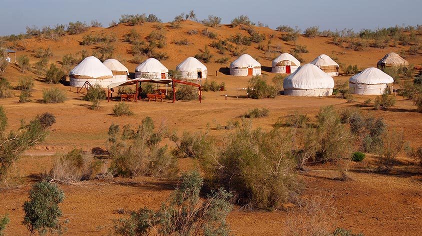
Safari yurt camp
The Safari yurt camp is located 6 km away from the west coast of Aydarkul lake. This yurt camp is regarded as the biggest and the most comfortable in Uzbekistan. Back in ancient times wonderers used to stay in such yurtas. These traditional habitations have century old history. To stay and rest in yurt camp is an unforgettable adventure. Here you can spend an evening by the fire with traditional music performed by local akyn, witness the sunrise and take a camel ride along Aydarkul lake.Safari yurt camp
Raboti Malik
There is a caravanserai on the restorated ancient road between Karmana and Bukhara called Raboti Malik (Rabot of the Ruler). It was erected in 70s of the XIth century in accord with the order issued by Shamsul-Mulk Nasr ibn Ibrohim (1068–1080), a representative of Qorakhonid dynasty and in the first half of the XIIth century it was restorated by his successor Arslon Muhammad ibn Sulaymon (1102–1130) also a representative of Qorakhanid dynasty. During the archeological excavations (70s of the XIXth and the early XXI century) the complicated structure of this complex has been defi ned. Archeologists found that it occupies a square of 100m X 100m and surrounded by strong walls and consists of two parts.
Sardoba - Raboti malik water reservoir
There is a water reservoir (sardoba) not far from the caravanserai with diameter of 13 meters covered with a huge dome. The walls of the reservoir were built of the bricks and it used to keep drinkable cold water during the whole hot summer. One of the historians compares the water of this reservation with the sacred water of the Holy Makka called Zamzam. It used to play the role of an inn for caravans and for individual travelers.
This caravanserai served dutifully up to the XVIII century. It is supposed to have served such well known historical fi gures as Temur the Great and his successors, Bukharian khans, ambassadors to the khanate, trading caravans and travelers. A small village called Rabot is said to have been erected near the sardoba in XIXth century and early XXth centuries.
Nuratau Mountain villages
Nuratau Mountains are home to many ancient villages and the settlements. There are three main ethnic groups Uzbeks, Tajiks and Kazakhs that populate Nuratau Mountains and Kyzyl-Kum steppe. Being the biggest community in the area, Uzbeks arrived to the area in the 13th century from the north of the present Kazakhstan. Second biggest ethnic group, Tajiks have more ancient settlement history dating back to the time of Alexander the Greats reign in Central Asia. Third small ethnic group Kazaks before settling in the beginning of the 20th century were living nomadicly in the yurts and moving permanently from place to place in Kyzyl-Kum desert.
Present development of ecotourism is concentrated in villages of Eski Forish, Asraf, Uhum, Hayat and Sentob inhabited with ethnic Tajik people. Nurata mountains
Eski Forish village
Eski Forish village has 1110 inhabitants. The village has a health post with a nurse and the secondary school. In the village, there are three small shops and a few home vendors, where basic groceries as well as biscuits, sweets, mineral water, beer, wine and cigarettes can be obtained. All the houses in the village are connected to the electricity network.
The name Eski Forish means old Forish. Eski Forish is called Porasht in Tajik language. The word Porasht has its roots in the Sogdian language and means “place surrounding a fortress”. The ancient village of Porasht was situated higher up in the valley. The ruins of houses, mosques and ancient mills can still be seen. The old village has been abandoned in the 17th century. The ruins of three old mosques (Mullodehkon, Arabboy and Merganboy) have been found in the Eski Forish area. Not far from the village, there is an ancient petroglyph site.
Asraf village
Asraf is a very small village located between Eski Forish and Uhum. There are 18 families living in the village at the present. It has its own small elementary school. After fourth grade children have to go to school in the village of Uhum.
Asraf is located very close to the Nuratau Nature Reserve, which unfortunately is not accessible to the public, but there are good hiking paths at the edges of the reserve. In the village there are two rivers the Arsaf and the Xushrud, which are fed by two springs the Chashmai Azizmurod and the Chashmai Abdulloi Naymon.
The customs of people in Asraf used to differ slightly from neighboring villages. During weddings for example, various activities like Kupkari were organized. Till the 1960s, the wedding celebration lasted 6-10 days. Ceremonies took place in the evenings around the fire.
Uhum village
Uhum village has two schools and a new technical collage built in 2009. There are several small shops where basic groceries as well as biscuits, sweets, mineral water, beer, wine and cigarettes can be obtained. On Sunday, a village bazaar is held, where vendors from the region offer their products. Uhum has a health post with a doctor and a nurse. There are seven cemeteries in Uhum, some of them are ancient. In the village there are five electric and three water driven mills for grinding grain. Uhum has a hair dresser near the bus station. In the Uhum valley, there is no mobile phone reception. All the houses in Uhum connected to electricity network.
In the village Uhum there are five ancient mosques and seven old cemeteries (Chilgazato, Guji G’ozi, Xazrati Bibi, Shoxidon, Azizon, Xisorato, Xazrati Eshonbobo). Other interesting historical sites are the ruins of the ancient Xonkeldi fortress in Uhum and the ruins of Korg’on fortress in Upper Uhum and a small petroglyphs site.
Uhum used to be a larger village in the past. In the 1950th the Soviet Government moved 608 families to other regions (Jizzakh, Kazakhstan, Sirdarya) where laborers were needed in the cotton fields. This is why you will see a lot of abandoned houses in Uhum.Uhum village
Hayat village
Hayat has 650 inhabitants. The village has an elementary school. A new technical college was built down in the valley in Uhum in 2009. There is a shop where basic groceries as well as biscuits, sweets, mineral water, beer, wine and cigarettes can be obtained. The village has its own cemetery. In the village, there are mills for grinding grain.
There are several legends about how the village came into being. According to one of them, there was a long lasting drought in the area. In search for water, a farmer came to the valley and saw fog and clouds and concluded that there must be water in the area. He told other villagers and they decided that this must be a good place to settle. Hence, they moved there and named the village Hoyat, which means life. Another legend says that during a severe drought all springs and wells in the neighboring villages dried up, but the spring in Hayat still produced water. That is why people called it spring of life (hoyat). In Hayat village there was a fortress called Shoxi Korgon that was located on a hill making it difficult for enemies to conquer. 10-15 people could defend it against 500 enemies. The ruins of the fortress can be visited.
Sentob village
Sentob village has two secondary schools and a health post with a doctor and a nurse. There are five small shops where basic groceries as well as biscuits, sweets, mineral water, soft drinks, beer, wine and cigarettes can be obtained. Near the minibus stop there is a hair dresser. There are three water mills and one electric mill for grinding grain. Only in some parts of the village, there is cellphone reception. All the houses in Sentob are connected to the electricity network. Sentob is the biggest and most ancient among other villages of Nuratau Mountain range. There are many legends about the origin of the name of the village. Legend says that the original name of the village was “Simtob”, which means “shining like silver” in the local language. The water of the springs and rivers in the village looks like silver, when it reflects in the sun.Sentob silk cocons
See our tours:
Tour MTHC 11. Colors & perfumes of Uzbekistan: Dome+Desert+Mountain
Uzbekistan Rural life of Uzbek village tour